road-safety
 Naresh Gangwar
Create an App name TRAJYX.TRAJYX is an AI-powered predictive road safety and traffic intelligence platform that analyzes CCTV footage to detect and track vehicles, identify traffic violations, analyze vehicle trajectories, detect near-miss situations, and predict potential collision risks. It generates dynamic risk zones and heatmaps, while its connected mobile app uses real-time GPS to alert drivers about upcoming high-risk areas through notifications, beeps, and voice warnings—helping prevent accidents before they happen.


Comments (0)
Sign in to leave a comment
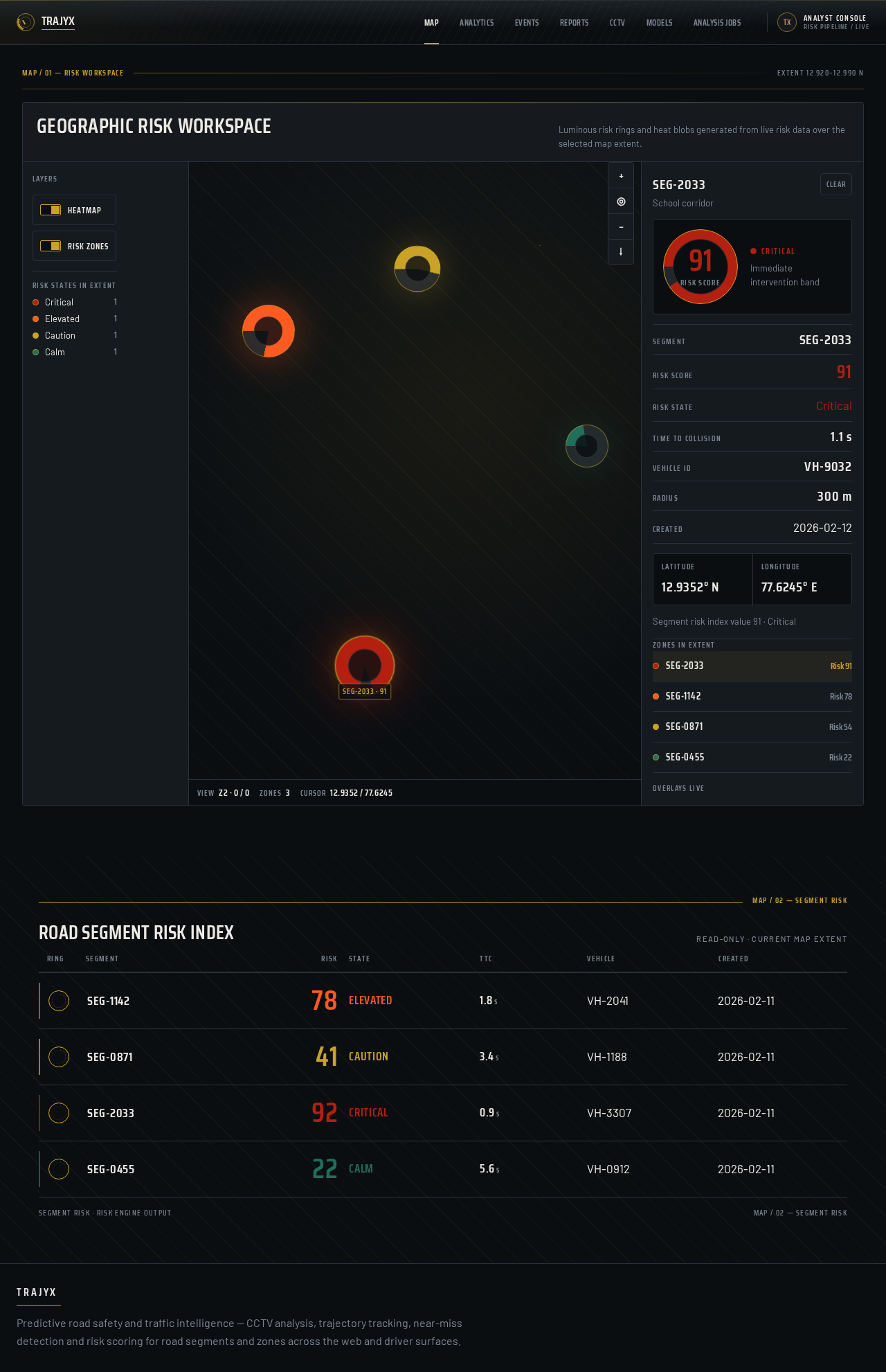
Geographic risk workspace
Luminous risk rings and heat blobs generated from live risk data over the selected map extent.
Road Segment Risk Index
Read-only · Current map extent
- SEG-11420
- Risk state
- elevated
- TTC
- 1.8 s
- VEHICLE ID
- VH-2041
- CREATED
- 2026-02-11
- SEG-08710
- Risk state
- caution
- TTC
- 3.4 s
- VEHICLE ID
- VH-1188
- CREATED
- 2026-02-11
- SEG-20330
- Risk state
- critical
- TTC
- 0.9 s
- VEHICLE ID
- VH-3307
- CREATED
- 2026-02-11
- SEG-04550
- Risk state
- calm
- TTC
- 5.6 s
- VEHICLE ID
- VH-0912
- CREATED
- 2026-02-11
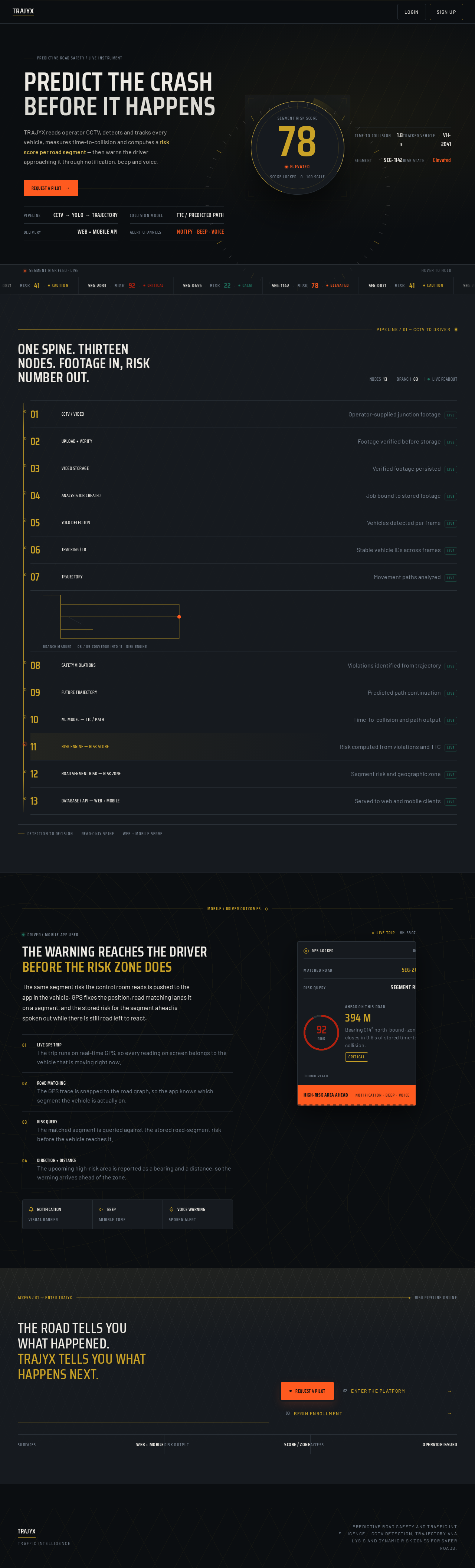
Predictive Road Safety / Live Instrument
Predict the crashBefore it happens
TRAJYX reads operator CCTV, detects and tracks every vehicle, measures time-to-collision and computes a risk score per road segment — then warns the driver approaching it through notification, beep and voice.
- Pipeline
- CCTV → YOLO → Trajectory
- Collision model
- TTC / Predicted Path
- Delivery
- Web + Mobile API
- Alert channels
- Notify · Beep · Voice
- Time to collision
- 1.8 s
- Tracked vehicle
- VH-2041
- Segment
- SEG-1142
- Risk state
- Elevated
- SEG-1142RISK 78ELEVATED
- SEG-0871RISK 41CAUTION
- SEG-2033RISK 92CRITICAL
- SEG-0455RISK 22CALM
One spine. Thirteen nodes. Footage in, risk number out.
- 01CCTV / VIDEOOperator-supplied junction footagelive
- 02UPLOAD + VERIFYFootage verified before storagelive
- 03VIDEO STORAGEVerified footage persistedlive
- 04ANALYSIS JOB CREATEDJob bound to stored footagelive
- 05YOLO DETECTIONVehicles detected per framelive
- 06TRACKING / IDStable vehicle IDs across frameslive
- 07TRAJECTORYMovement paths analyzedlive
- 08SAFETY VIOLATIONSViolations identified from trajectorylive
- 09FUTURE TRAJECTORYPredicted path continuationlive
- 10ML MODEL — TTC / PATHTime-to-collision and path outputlive
- 11RISK ENGINE — RISK SCORERisk computed from violations and TTClive
- 12ROAD SEGMENT RISK — RISK ZONESegment risk and geographic zonelive
- 13DATABASE / API — WEB + MOBILEServed to web and mobile clientslive
Driver / Mobile App User
The warning reaches the driver
before the risk zone does
The same segment risk the control room reads is pushed to the app in the vehicle. GPS fixes the position, road matching lands it on a segment, and the stored risk for the segment ahead is spoken out while there is still road left to react.
- 01Live GPS Trip
The trip runs on real-time GPS, so every reading on screen belongs to the vehicle that is moving right now.
- 02Road Matching
The GPS trace is snapped to the road graph, so the app knows which segment the vehicle is actually on.
- 03Risk Query
The matched segment is queried against the stored road-segment risk before the vehicle reaches it.
- 04Direction + Distance
The upcoming high-risk area is reported as a bearing and a distance, so the warning arrives ahead of the zone.
Ahead on this road
418 M
Bearing 014° north-bound · zone closes in 0.9 s of stored time-to-collision.
Critical
No comments yet. Be the first!