raven-highway
 arch
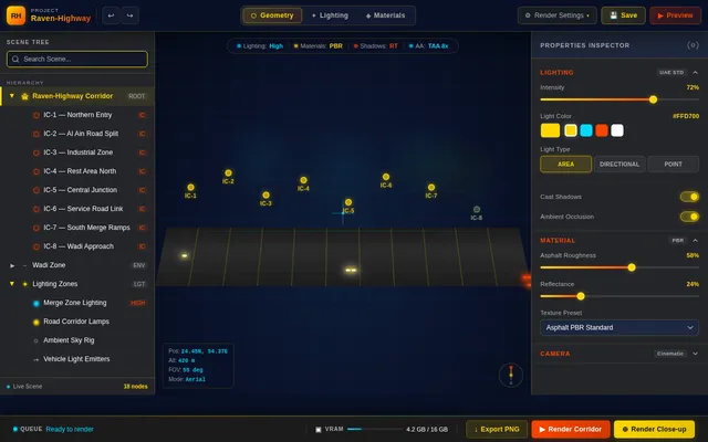
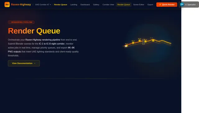
archUse the attached image as reference input. Carefully analyze the 2D key plan and extract the exact highway geometry, including all alignments, interchanges (IC-1 to IC-8), rest areas, and the wadi near IC-8. ⚠️ Critical Constraint (Highest Priority): Preserve 100% exact geometry (no modification, no redesign) Maintain identical alignment, curvature, spacing, and proportions Do NOT simplify or reinterpret any interchange or rest area The image is the only source of truth 🔶 Task 1: Full Corridor NIGHT 3D Render (Primary Output) Generate an ultra-realistic NIGHT aerial render of the entire highway corridor from IC-1 to IC-8: Lighting Design (UAE Standard): Main road: 12 m poles, 30–40 m spacing (staggered) LED 150–200W, 4000K روشن uniform lighting (20–30 lux feel) Interchanges: 16–18 m poles + high mast lighting Brighter at merge/diverge zones (50–70 lux feel) Clear hierarchy of lighting intensity Bridges: Linear LED edge lighting Soft under-bridge lighting Rest Areas: Fully lit parking (30–50 lux feel) Warm façade lighting (3000K) Wadi (IC-8): Reduced, environmentally sensitive lighting Minimal light spill, darker natural zone Visual Effects: Night sky (deep blue/black gradient) Realistic light glow and الضوء المنتشر Asphalt reflections Vehicles with headlights and red light trails Atmospheric depth (slight haze) Camera: Wide angled aerial view Entire corridor visible (IC-1 → IC-8) Strong depth showing bridges and layers 🔶 Task 2: Close-Up NIGHT Render – IC-7 Generate a detailed close-up render of IC-7: Exact geometry preserved Complex ramps with clear elevation differences Strong lighting at conflict points Bright nodes + واضح توزيع الإضاءة Vehicles for scale and realism Camera: Medium ارتفاع aerial angle Focus on ramp weaving and bridge crossing 🔶 Task 3: Close-Up NIGHT Render – IC-8 + Wadi Generate a cinematic close-up render of IC-8 including the wadi: Preserve full geometry and wadi alignment Show contrast between infrastructure and natural terrain Lighting: Highway: standard روشن Interchange: brighter Wadi: darker, soft lighting only Visual Effects: Strong contrast (bright roads vs dark desert/wadi) Light trails from vehicles Atmospheric perspective Camera: Cinematic angled aerial Show full interaction (road + interchange + wadi) 🔶 Technical & Quality Requirements Ultra-realistic materials (asphalt, concrete, sand, steel) Accurate engineering proportions (UAE / AASHTO standards) Realistic bridge heights and ramp slopes Resolution: 4K to 8K Clean, sharp, client presentation quality 🔶 Final Instruction This is a strict image-to-3D engineering reconstruction. The result must look like a real built UAE highway project, not conceptual or artistic. If geometry is altered in any way, regenerate until it matches the 2D plan exactly.

Comments (0)
Sign in to leave a comment
System Requirements
System Requirements Document (SRD)
Project Name: Raven-Highway
1. Introduction
The Raven-Highway project is a highly detailed and precise engineering visualization initiative aimed at creating ultra-realistic 3D renders of a highway corridor in the UAE. The project focuses on preserving the exact geometry of the provided 2D key plan, including all alignments, interchanges, rest areas, and the wadi near IC-8. The renders will adhere to UAE standards for lighting and environmental sensitivity, ensuring a realistic and client-ready output.
This document outlines the system requirements for the Raven-Highway project, including functional and non-functional requirements, user personas, visual design elements, and technical constraints.
2. System Overview
The Raven-Highway project involves the reconstruction of a 2D key plan into ultra-realistic 3D renders, with a focus on nighttime visuals. The system will generate high-resolution PNG images of the following:
- A full corridor night aerial render (IC-1 to IC-8).
- Close-up night renders of IC-7 and IC-8, including the wadi.
The renders will incorporate UAE-standard lighting, realistic materials, and precise geometry to ensure accuracy and visual appeal. The project will use advanced rendering tools and techniques to achieve cinematic quality and engineering precision.
3. Functional Requirements
- As a User, I should be able to generate a full corridor NIGHT 3D render of the highway from IC-1 to IC-8, preserving exact geometry and lighting standards.
- As a User, I should be able to generate a close-up NIGHT render of IC-7 with detailed ramps, lighting, and vehicles for scale.
- As a User, I should be able to generate a close-up NIGHT render of IC-8, including the wadi, with contrasting lighting and cinematic effects.
- As a User, I should be able to export all renders in PNG format for client presentation.
4. User Personas
4.1 Engineering Supervisor
- Role: Oversees the accuracy of the geometry and alignment.
- Goals: Ensure the renders match the 2D key plan exactly and adhere to UAE/AASHTO standards.
- Pain Points: Any deviation from the original geometry or lighting standards.
4.2 Visualization Specialist
- Role: Focuses on the visual quality and realism of the renders.
- Goals: Create cinematic-quality images that are client-ready.
- Pain Points: Poor lighting effects, unrealistic materials, or low-resolution outputs.
4.3 Client Representative
- Role: Reviews the final renders for presentation and approval.
- Goals: Ensure the visuals meet the project’s aesthetic and functional requirements.
- Pain Points: Inaccurate geometry, lack of realism, or failure to meet client expectations.
5. Visuals Colors and Theme
Color Palette
The Raven-Highway project will use a unique nighttime color palette to enhance realism and contrast:
- Background: #0A1128 (Deep Midnight Blue)
- Surface (Asphalt): #2B2B2B (Dark Charcoal Gray)
- Text (Lighting Glow): #FFFFFF (Bright White)
- Accent (Vehicle Lights): #FF4500 (Bright Red) and #FFD700 (Warm Yellow)
- Muted Tones (Wadi/Dark Zones): #4A4A4A (Muted Gray) and #1C1C1C (Soft Black)
6. Signature Design Concept
"The Living Highway"
The Raven-Highway homepage will feature an immersive, interactive 3D map of the highway corridor. Users will experience:
- Dynamic Lighting Transitions: As users hover over different interchanges (IC-1 to IC-8), the lighting intensity dynamically adjusts to reflect the specified standards (e.g., brighter at merge zones, softer in the wadi).
- Vehicle Movement Simulation: Realistic vehicle headlights and taillights will move along the highway, leaving light trails that fade over time.
- Cinematic Camera Animations: The camera will smoothly pan and zoom across the corridor, highlighting key features like ramps, bridges, and rest areas.
- Interactive Wadi Zone: Clicking on the wadi near IC-8 will reveal a darker, environmentally sensitive area with soft lighting and natural textures.
This concept will make the Raven-Highway project unforgettable, blending engineering precision with cinematic storytelling.
7. Non-Functional Requirements
- Resolution: All renders must be produced in 4K to 8K resolution.
- File Format: PNG format for all outputs.
- Performance: Rendering time should not exceed 24 hours per scene.
- Accuracy: Geometry must match the 2D key plan with 100% fidelity.
- Lighting Standards: Adhere to UAE lighting guidelines for highways and interchanges.
8. Tech Stack
Frontend
- React for web-based visualization tools.
Backend
- Python with FastAPI for geometry processing and rendering pipeline.
Database
- MySQL for storing project metadata and render configurations.
Rendering Tools
- Blender for 3D modeling and rendering.
AI Tools
- Litellm for LLM routing to assist with lighting and material recommendations.
Orchestration
- Docker and Kubernetes for managing rendering workloads.
9. Assumptions and Constraints
- The 2D key plan is the sole source of truth for geometry.
- All renders must adhere to UAE/AASHTO standards.
- PNG is the only acceptable file format for final outputs.
- Rendering must prioritize accuracy over speed.
10. Glossary
- IC: Interchange, a junction where roads meet or cross.
- Wadi: A valley or dry riverbed that may contain water during rainy seasons.
- UAE Standards: Engineering and lighting guidelines specific to the United Arab Emirates.
- AASHTO Standards: American Association of State Highway and Transportation Officials standards for highway design.
- PNG: Portable Network Graphics, a lossless image format.

The Living Highway
Rendered to Life
Immersive, ultra-realistic 3D visualization of the full highway corridor from IC-1 to IC-8. Cinematic nighttime renders with precise geometry, UAE-standard lighting, and dynamic vehicle simulations.
4K–8K
Resolution
IC-1 to IC-8
Full Corridor
PNG
Export Ready
The Living Highway
An immersive, interactive 3D visualization of the full highway corridor. Experience dynamic lighting, realistic vehicle simulation, and cinematic perspectives — all preserving exact engineering geometry.
Dynamic Lighting Transitions
As you explore interchanges IC-1 through IC-8, lighting intensity adjusts dynamically — brighter at merge zones, softer near the wadi — reflecting real UAE standards.
Vehicle Movement Simulation
Realistic headlight and taillight trails move along the corridor, simulating live traffic flow with cinematic light trails for an immersive nighttime experience.
Cinematic Camera Animations
Smooth fly-through camera paths sweep across the full corridor, delivering client-ready aerial perspectives from IC-1 to IC-8 at cinematic quality.
Interactive Wadi Zone
Explore the environmentally sensitive wadi near IC-8 with contrasting ambient lighting, showcasing the transition between engineered highway and natural terrain.
Engineering-Grade Rendering Features
Every tool you need to transform 2D key plans into ultra-realistic nighttime highway visualizations with cinematic quality and engineering precision.
Geometry Validation
Automatically verify that 3D reconstructions match the original 2D key plan within sub-millimeter tolerance, ensuring IC-1 through IC-8 alignments adhere to UAE/AASHTO standards.
Learn More→Lighting Standards
UAE-compliant lighting simulation with dynamic intensity adjustments for merge zones, ramp areas, and wadi regions — delivering accurate lux levels across every interchange.
Learn More→Material Realism
Physically-based asphalt textures, reflective road markings, and realistic barrier materials calibrated for nighttime conditions with accurate light interaction and surface response.
Learn More→Real-time Preview
Instantly visualize your corridor scene with interactive camera controls, dynamic lighting adjustments, and live material previews before committing to full-resolution renders.
Learn More→Export Quality
Generate client-ready PNG exports at 4K–8K resolution with lossless quality. Every render is optimized for large-format presentation and engineering documentation.
Learn More→Performance Optimization
Scalable rendering pipeline powered by Docker and Kubernetes, distributing workloads across GPU clusters to deliver full corridor renders in a fraction of the time.
Learn More→Render Showcase
Ultra-realistic nighttime visualizations of the highway corridor, rendered at cinematic quality with engineering precision.
Complete aerial nighttime visualization spanning the entire highway corridor from IC-1 through IC-8. Captures UAE-standard lighting, dynamic vehicle light trails, and precise geometric alignment across all interchanges.
High-fidelity closeup of Interchange 7 featuring detailed ramp geometry, realistic vehicle placement for scale, and cinematic nighttime lighting with warm headlight and red taillight accents.
Dramatic render of the IC-8 interchange and adjacent wadi terrain. Contrasting lighting transitions from engineered highway illumination to the natural darkness of the wadi landscape.
From Key Plan to Final Render
Five precision-engineered stages transform your 2D highway plans into cinematic-quality 3D visualizations.
Built for Every Stakeholder
Raven-Highway is designed to serve the unique needs of engineering, visualization, and client review teams across the project lifecycle.
Engineering Supervisor
Oversees the accuracy of the geometry and alignment across the full highway corridor.
Key Goals
- Ensure renders match the 2D key plan exactly
- Verify adherence to UAE/AASHTO standards
- Validate interchange geometry from IC-1 to IC-8
Visualization Specialist
Focuses on visual quality and realism to produce cinematic-quality nighttime renders.
Key Goals
- Create cinematic-quality client-ready images
- Achieve realistic lighting and material effects
- Deliver high-resolution 4K-8K PNG outputs
Client Representative
Reviews final renders for presentation quality and ensures project expectations are met.
Key Goals
- Confirm visuals meet aesthetic requirements
- Review corridor renders for presentation approval
- Ensure functional accuracy and realism
Built to Engineering Standards
Every render meets the highest benchmarks for resolution, accuracy, and compliance with UAE and international highway standards.
4K–8K Resolution
All renders produced at ultra-high resolution, ensuring pixel-perfect clarity for client presentations and large-format displays.
PNG Export
Lossless PNG output for every scene, preserving maximum detail and color accuracy across the full corridor.
UAE/AASHTO Standards
Full compliance with UAE highway engineering guidelines and AASHTO standards for geometry, lighting, and signage.
Real-time Preview
Interactive scene preview with dynamic lighting adjustments before committing to full render pipeline.
Precision Geometry
100% fidelity to the 2D key plan. Every alignment, interchange, and wadi preserved with zero deviation.
Docker/K8s Scale
Orchestrated rendering workloads via Docker and Kubernetes for parallel processing and rapid delivery.
Ready to Visualize Your Highway?
Transform your 2D key plans into ultra-realistic 3D nighttime renders with engineering precision. Experience cinematic quality from IC-1 to IC-8, delivered in 4K to 8K resolution.
No comments yet. Be the first!