polar-tourism
 ROY
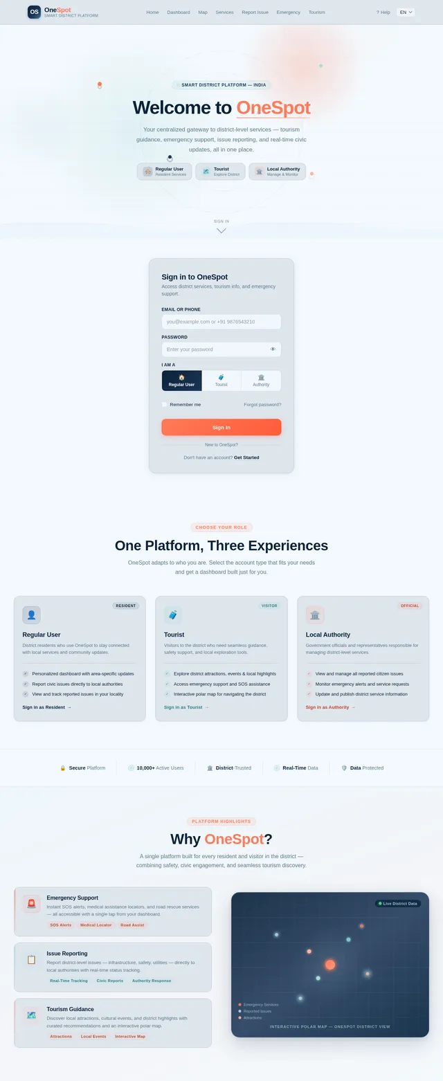
ROYthe OneSpot application is proposed as a Smart District Tourism and Service Platform. The system is designed to integrate multiple essential services such as tourism guidance, emergency support, and citizen interaction into a single digital platform. OneSpot aims to act as a central hub where users can access all relevant district-level information without switching between multiple applications. The system focuses on providing a seamless and user-friendly experience while ensuring that the information presented is accurate and reliable. Unlike large commercial platforms that focus on complex features and large-scale operations, OneSpot is designed with a localized approach, specifically targeting district-level needs. This makes the system more practical, efficient, and suitable for real-world implementation. The main purpose of the OneSpot project is to develop a system that simplifies access to district-level information and services. The application is intended to: • Provide a centralized platform for users • Improve accessibility to local services • Enhance the travel experience for tourists • Enable better communication between citizens and authorities The system is designed to be practical, user-friendly, and aligned with real-world requirements.

Comments (0)
Sign in to leave a comment
System Requirements
System Requirements Document (SRD)
Project Name: OneSpot
1. Introduction
The OneSpot project is a localized Smart District Tourism and Service Platform designed to integrate essential services such as tourism guidance, emergency support, and citizen interaction into a single digital platform. Unlike large-scale commercial platforms, OneSpot focuses on district-level needs, offering a practical and user-friendly experience tailored to the real-world requirements of users in India.
The primary objectives of OneSpot are:
- To provide a centralized platform for users to access district-level information and services.
- To improve accessibility to local services for both residents and tourists.
- To enhance the travel experience for tourists by offering seamless guidance and support.
- To enable better communication between citizens and local authorities.
This document outlines the system requirements for OneSpot, ensuring that the platform is designed to meet the needs of its diverse user base effectively.
2. System Overview
OneSpot is a login-based platform that provides distinct dashboards for three primary user personas: regular users, tourists, and local authorities. Each dashboard is tailored to the specific needs of the user type, ensuring a personalized and efficient experience.
Key features of the system include:
- Tourism Guidance: Access to district-level tourism information, including attractions, events, and local highlights.
- Emergency Support: Critical features such as SOS alerts, medical assistance locators, and road assistance services.
- Citizen Interaction: A platform for users to report issues, communicate with local authorities, and stay informed about district-level updates.
- Selective Re-run Capability: Users can trigger specific system functions (e.g., refreshing dashboards or reloading emergency data) without restarting the entire application.
The system is designed to be intuitive, reliable, and aligned with the needs of users in India, ensuring accessibility and practicality for all.
3. Functional Requirements
As story points:
- As a Regular User, I should be able to log in to access my personalized dashboard.
- As a Tourist, I should be able to log in to access my personalized dashboard.
- As a Local Authority, I should be able to log in to access my personalized dashboard.
- As a Regular User, I should be able to report issues directly from my dashboard.
- As a Tourist, I should be able to report issues directly from my dashboard.
- As a Local Authority, I should be able to view reported issues on my dashboard.
- As a Regular User, I should be able to view reported issues relevant to my area on my dashboard.
- As a Tourist, I should be able to view reported issues relevant to my location on my dashboard.
- As a User, I should be able to trigger selective re-run capabilities for refreshing specific system functions like dashboards or emergency data.
- As a User, I should be able to access emergency support features such as SOS alerts, medical assistance locators, and road assistance services.
4. User Personas
1. Regular Users
- Description: Residents of the district who use the platform to access local services, report issues, and stay informed about updates.
- Key Features: Personalized dashboard, issue reporting, access to local services.
2. Tourists
- Description: Visitors to the district who use the platform for tourism guidance, emergency support, and issue reporting.
- Key Features: Personalized dashboard, issue reporting, access to tourism information.
3. Local Authorities
- Description: Government officials or representatives responsible for managing district-level services and addressing reported issues.
- Key Features: Dashboard displaying reported issues, tools for managing and resolving issues.
5. Visuals Colors and Theme
The visual identity of OneSpot reflects its focus on tourism, safety, and community engagement. The color palette is designed to evoke trust, warmth, and exploration.
- Background: #F5FAFF (Polar Ice White)
- Surface: #E1EDF7 (Soft Arctic Blue)
- Text: #0D1F33 (Deep Midnight Blue)
- Accent: #FF6F3C (Aurora Orange)
- Muted Tones: #B8D8E8 (Frosted Glacier Blue)
This palette creates a clean, modern, and approachable aesthetic that aligns with the platform's purpose.
6. Signature Design Concept
Interactive Polar Map Dashboard with Emergency Features
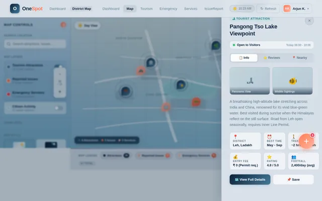
The landing page and dashboards will feature an interactive polar map as the central design element. This map will dynamically display key locations, reported issues, and emergency services in real-time.
- Visuals: The map will have a sleek, semi-transparent overlay with glowing markers for attractions, reported issues, and emergency services.
- Animations: Markers will pulse gently to indicate activity, and clicking on a marker will open a detailed pop-up with relevant information.
- Transitions: Smooth zoom-in and zoom-out transitions will allow users to explore the map intuitively.
- Micro-interactions: Hovering over a marker will display a brief tooltip, while clicking will provide detailed information.
- Selective Re-run Capability: Users can refresh specific map layers (e.g., emergency services, reported issues) without reloading the entire map.
- Color Shifts: The map's background will subtly change based on the time of day, transitioning from a bright, sunny theme during the day to a calm, starry theme at night.
This interactive map will serve as the focal point of the platform, offering users an engaging and visually striking way to navigate the system while maintaining high functionality.
7. Non-Functional Requirements
- The system must support a minimum of 10,000 concurrent users.
- The platform should load within 3 seconds on a standard 4G connection.
- Data accuracy must be maintained with a 99.9% reliability rate.
- The system must comply with Indian data protection laws and regulations.
- The platform should be accessible on both web and mobile devices.
- Selective re-run capabilities must execute within 1 second for seamless user experience.
8. Tech Stack
Frontend
- React for Web
- React Native for Mobile App
Backend
- Python
- FastAPI
Database
- MySQL (with Alembic for migrations)
AI Models
- GPT 5.4 for user-friendly responses
AI Tools
- Langchain
- Litellm for LLM Routing
Orchestration
- Docker for local orchestration
- Kubernetes for server-side orchestration
9. Assumptions and Constraints
- Users will have access to a stable internet connection to use the platform.
- The system will initially target a single district in India, with potential for expansion.
- Notification functionality for reported issues will be implemented in a future phase.
- Emergency services data will be provided and maintained by local authorities.
- Selective re-run capabilities will be limited to specific system functions (e.g., refreshing dashboards, reloading emergency data).
10. Glossary
- Dashboard: A user interface that provides an overview of key information and tools.
- SOS: An emergency alert feature for requesting immediate assistance.
- Local Authorities: Government officials or representatives responsible for managing district-level services.
- Interactive Polar Map: A dynamic map feature that displays key locations, reported issues, and emergency services.
- Selective Re-run Capability: A feature allowing users to refresh specific system functions without restarting the entire application.
- Micro-interactions: Small, subtle animations or responses to user actions that enhance the user experience.

Explore Your District.
Stay Safe. Connect.
Your centralized platform for district-level tourism guidance, emergency support, and citizen interaction — designed to bring communities and visitors closer together.
Explore Your District at a Glance
A real-time polar map dashboard with glowing markers for attractions, reported issues, and emergency services. Tap, zoom, and discover everything your district offers.
Tailored for Every User
Polar-Tourism provides distinct, personalized dashboards for residents, tourists, and local authorities — ensuring everyone gets exactly what they need.
Regular Users
Residents of the district who use the platform to access local services, report issues, and stay informed about community updates.
Key Responsibilities
- Access personalized dashboard with local updates
- Report civic issues directly from the platform
- Stay informed about district-level developments
Quick Access
Tourists
Visitors to the district who use the platform for tourism guidance, emergency support, and seamless travel experiences.
Key Responsibilities
- Explore attractions with interactive maps and guides
- Access emergency support and SOS services
- Report issues encountered during travel
Quick Access
Local Authorities
Government officials responsible for managing district-level services, addressing reported issues, and ensuring community welfare.
Key Responsibilities
- View and manage reported issues on dashboard
- Coordinate emergency response and resolution
- Monitor district services and citizen feedback
Quick Access
Everything You Need in One Platform
Polar-Tourism brings together tourism guidance, safety tools, and civic services into a single, intuitive experience designed for your district.
Tourism Guidance
Access comprehensive district-level tourism information including attractions, events, local highlights, and curated travel itineraries tailored to your interests.
ExploreEmergency Support
Instantly access SOS alerts, locate nearby medical facilities, request road assistance, and connect with emergency services when you need help the most.
SafetyIssue Reporting
Report civic issues directly from your dashboard with photo evidence, location tagging, and real-time status tracking to keep your district running smoothly.
ReportReal-Time Map
Explore an interactive polar map dashboard with glowing markers for attractions, reported issues, and emergency services updated in real time.
NavigateCitizen Interaction
Communicate directly with local authorities, receive district-level updates, participate in community discussions, and stay informed about local governance.
ConnectMulti-Device Access
Seamlessly access the platform on desktop, tablet, or mobile with a fully responsive design that adapts to any screen size for on-the-go convenience.
AnywhereYour Journey with Polar-Tourism
Getting started is simple. Follow these five easy steps to connect with your district and access the services you need.
Sign Up or Log In
Create your free account or log in with your existing credentials to access your personalized district dashboard.
Explore Your Dashboard
Navigate your tailored dashboard with quick access to tourism info, local services, and community updates.
Access District Services
Use the interactive map to discover attractions, find emergency services, and explore tourism highlights in real time.
Report or Request Help
Easily report local issues or request assistance directly through the platform with our streamlined reporting tools.
Receive Support
Local authorities review and respond to your reports. Track resolution status and stay informed with real-time updates.
Built for Trust. Designed for Safety.
Polar-Tourism ensures your data is protected and services remain available around the clock, meeting the highest standards of Indian regulatory compliance.
Enterprise-grade reliability ensuring uninterrupted access to all district services, 24/7.
Fully compliant with Indian data protection regulations and IT Act 2000 guidelines.
Seamless experience across desktop, tablet, and mobile devices for all user personas.
Security & Compliance
- ✓Indian IT Act 2000 Compliant
- ✓SSL/TLS Encrypted Data Transfer
- ✓Role-Based Access Control
- ✓Regular Security Audits
- ✓Secure Authentication Protocols
Performance Metrics
Certifications & Standards
Ready to Explore Your District?
Access tourism guidance, emergency support, and community services — all in one platform built for your district. Whether you are a resident, tourist, or local authority, Polar-Tourism has you covered.
Frequently Asked Questions
Everything you need to know about using Polar-Tourism for district-level services, tourism guidance, and emergency support.
Once you are logged in, navigate to your Dashboard and click on "Report Issue." Fill out the form with details about the issue, including its location, category, and a brief description. Your report will be sent directly to the relevant local authorities for review and resolution.
The Interactive Polar Map is the signature feature of Polar-Tourism. It displays a dynamic, real-time map of your district showing tourist attractions, reported issues, and emergency services as glowing markers. You can zoom, pan, and click on markers to view detailed information. The map even adjusts its theme based on the time of day.
Polar-Tourism is fully compliant with Indian data protection laws and regulations. All personal data is encrypted both in transit and at rest. We maintain a 99.9% data reliability rate, and our systems are regularly audited to ensure the highest standards of security and privacy for all users.
Yes! Polar-Tourism is designed as a multi-platform solution. You can access the full platform through any modern web browser on your phone or tablet, and a dedicated React Native mobile app is available for both Android and iOS devices, optimized for touch interactions and on-the-go usage.
The SOS feature is available from your Dashboard under the Emergency section. In case of an emergency, simply tap the SOS button to send an immediate alert to nearby emergency services, including medical assistance and road assistance. Your GPS location is automatically shared to ensure the fastest possible response.
Polar-Tourism supports three user types: Regular Users (district residents who access local services and report issues), Tourists (visitors who get tourism guidance, emergency support, and can report issues), and Local Authorities (officials who manage district services, review reports, and update service information). Each role has a tailored dashboard.
Absolutely. When you submit an issue report, it appears on the Local Authority dashboard for your district. Officials can review the details, assign resources, and update the status of your report. You can track the progress of your reported issues directly from your own dashboard in real time.
Still have questions? Our support team is here to help you get the most out of Polar-Tourism.
Contact Support →
No comments yet. Be the first!