golden-jatayu
 Divya Rajput
# JATAYU Backend Architecture Generate a production-ready backend using Python FastAPI. Architecture: ## APIs POST /upload POST /analyze POST /chat GET /mission/{id} GET /report/{id} ## AI Agents IntentAgent MetadataAgent RouterAgent FusionAgent RSVQAAgent CDVQAAgent GeoReasonAgent SITREPAgent ## Context Engine Every mission creates a unique Mission ID. Store: * image paths * metadata * CRS * timestamps * previous queries * GeoJSON * flood masks ## Router Logic If 1 image → RSVQA If Optical + SAR → Fusion If Before + After → CDVQA ## Outputs Return JSON containing: * summary * confidence * area_km2 * gps_coordinates * geojson_path * execution_trace Generate clean modular folder structure and FastAPI routes. Design a LangGraph multi-agent workflow for JATAYU. Agents: Intent Agent Metadata Agent Router Agent Optical-SAR Fusion Agent Change Detection Agent GeoReason Agent SITREP Agent The router must decide the workflow based on: * number of images * modality * timestamps * user query Generate an execution graph and state schema. Output should be explainable and auditable. givme mea full working website

Comments (0)
Sign in to leave a comment
System Requirements
System Requirements Document for golden-jatayu
Introduction
This document outlines the system requirements for the JATAYU project, an interactive vision-language assistant designed for multimodal remote sensing image analysis through text queries. The project aims to address challenges in remote-sensing imagery analysis, such as complex GIS tools, cloud cover limitations, fragmented analysis, slow damage assessment, and lack of natural language access.
System Overview
JATAYU is a multi-agent framework that allows users to interact with satellite imagery using a conversational interface. It integrates various AI agents to perform tasks such as image validation, optical and SAR fusion, change detection, and geospatial reasoning. The system is designed to be explainable and auditable, providing outputs in JSON format with detailed execution traces.
Product Interpretation and Delivery Boundary
The JATAYU system is delivered as a web-based application with a backend powered by Python FastAPI. It supports user interactions through a conversational interface, allowing for natural language queries. The system is intended for use by remote sensing analysts, field officers, and data scientists. Access to the system requires user authentication to ensure secure handling of sensitive data and mission continuity. The application is designed to be scalable and capable of processing large datasets, subject to available computational resources.
Page Content and Component Coverage
Landing
- Information/State: Introduction to golden-jatayu, its purpose, and capabilities.
- Primary Actions: Navigate to Login.
- Components: Overview of features, benefits, and use cases.
Login
- Information/State: User authentication.
- Primary Actions: Log in to access the system.
- Components: Username and password fields, login button.
Dashboard
- Information/State: Summary of active missions.
- Primary Actions: Access mission details, start new analysis.
- Components: Mission list, quick access buttons.
Missions
- Information/State: List of all missions with identifiers and status.
- Primary Actions: Browse and resume missions.
- Components: Mission table, search and filter options.
Upload
- Information/State: Image upload interface.
- Primary Actions: Upload images to start a new mission.
- Components: File upload controls, metadata input fields.
Mission Details
- Information/State: Detailed view of a specific mission.
- Primary Actions: View progress, access stored data.
- Components: Metadata display, progress indicators.
Chat
- Information/State: Conversational interface for queries.
- Primary Actions: Submit natural language queries.
- Components: Chat input field, conversation history.
Analysis
- Information/State: Analysis workflow interface.
- Primary Actions: Initiate analysis based on uploaded data.
- Components: Workflow selection, execution progress.
Results
- Information/State: Display of analysis results.
- Primary Actions: Review JSON outputs.
- Components: Results summary, detailed data view.
Map
- Information/State: Geospatial visualization of results.
- Primary Actions: Explore map overlays and annotations.
- Components: Interactive map, overlay controls.
Reports
- Information/State: Compiled analysis reports.
- Primary Actions: Download and review reports.
- Components: Report list, download buttons.
Functional Requirements
APIs
- As a user, I want to upload images via the POST /upload API so that they can be processed for analysis.
- As a user, I want to analyze uploaded images via the POST /analyze API to receive actionable insights.
- As a user, I want to interact with the system using the POST /chat API to submit natural language queries.
- As a user, I want to retrieve mission details using the GET /mission/{id} API to track the progress and results of specific analyses.
- As a user, I want to access detailed reports using the GET /report/{id} API to review the findings of the analysis.
AI Agents
- As a user, I want the Intent Agent to understand my natural-language queries and map them to specific workflows.
- As a user, I want the Metadata Agent to validate GeoTIFF metadata, including CRS and timestamps.
- As a user, I want the Router Agent to select and execute the appropriate AI models based on my query and input modality.
- As a user, I want the Fusion Agent to perform optical and SAR image fusion for reliable flood detection.
- As a user, I want the RSVQA Agent to execute visual question answering on single images.
- As a user, I want the CDVQA Agent to conduct change analysis on before-and-after image pairs.
- As a user, I want the GeoReason Agent to convert image pixels into GPS coordinates and generate GeoJSON polygons.
- As a user, I want the SITREP Agent to compile analytical results, including maps, confidence scores, and damage statistics, into professional PDF and GeoJSON reports.
Context Engine
- As a user, I want each mission to generate a unique Mission ID for tracking and auditability.
- As a user, I want the system to store image paths, metadata, CRS, timestamps, previous queries, GeoJSON, and flood masks for each mission.
Router Logic
- As a user, I want the router to direct single images to the RSVQA Agent.
- As a user, I want the router to direct optical and SAR image pairs to the Fusion Agent.
- As a user, I want the router to direct before-and-after image pairs to the CDVQA Agent.
Outputs
- As a user, I want the system to return JSON outputs containing summary, confidence, area_km2, GPS coordinates, geojson_path, and execution_trace.
User Personas
Remote Sensing Analyst
- Context: Uses the interactive JATAYU assistant to upload and analyze satellite imagery.
- Primary Goal: To derive actionable insights for disaster management and urban planning.
- Responsibilities: Upload images, submit queries, review results and reports.
- Interactions: Engages with the system to perform detailed analyses and generate reports.
Field Officer
- Context: Utilizes natural language queries for field decision-making.
- Primary Goal: To obtain rapid, actionable insights from satellite data.
- Responsibilities: Submit queries, review analysis outputs, make field decisions.
- Interactions: Uses the system to quickly access and interpret data for immediate action.
Data Scientist
- Context: Integrates and validates data for accurate analysis.
- Primary Goal: To ensure the accuracy and reliability of the analysis.
- Responsibilities: Validate metadata, ensure data integrity, support analysis processes.
- Interactions: Works with the system to maintain data quality and support analytical accuracy.
Core User Flows
-
Image Upload and Analysis
- Starting Context: User accesses the Upload page.
- Action: User uploads images via the POST /upload API.
- Result: System generates a unique Mission ID and stores relevant metadata.
- Continuation: User submits a query via the POST /chat API.
- Outcome: Router Agent selects the appropriate AI models based on the query.
- Completion: Specialist AI models execute the analysis, and results are delivered in JSON format.
-
Report Generation and Retrieval
- Starting Context: User accesses the Reports page.
- Action: User requests a report via the GET /report/{id} API.
- Result: SITREP Agent compiles the analysis results into a PDF report.
- Completion: User downloads and reviews the report.
Visuals Colors and Theme
- Color Theme: Earth tones to reflect the geospatial nature of the application.
- Design Style: Clean and professional with a focus on usability and clarity.
- Palette: Background #F4F4F4, Surface #FFFFFF, Text #333333, Primary #FF8C00, Accent #008080, Muted #CCCCCC.
Signature Design Concept
- Interactive Chat Interface: Allows users to submit queries and receive responses in a conversational format.
- Map Visualization: Provides a visual representation of analysis results with overlays and annotations.
Interaction Model & Motion Direction
- Interaction Model: Conversational and intuitive, allowing users to interact with the system using natural language.
- Motion Tempo: Restrained; Hero Dimensionality: Flat.
- Hero Direction: A structured, modular hero with a diagrammatic representation of the multi-agent workflow on a warm grey background, using orange and teal accents for interactive highlights.
Non-Functional Requirements
- Performance: The system should process and return results within a reasonable timeframe to support real-time decision-making.
- Scalability: Capable of handling multiple concurrent users and large datasets.
- Security: Ensure secure access and data protection throughout the system.
Tech Stack
- Frontend: React, TypeScript, Tailwind CSS, Stitch UI Design, Framer Motion
- Backend: FastAPI, LangGraph, GPT-5 (LLM), PyTorch
- Geospatial & Database: PostgreSQL, PostGIS, Rasterio, GDAL
- AI Models & Datasets: BigEarthNet (Adaptation), RSVQA, VRSBench, CDVQA
Assumptions and Constraints
- The system assumes access to high-quality satellite imagery and metadata.
- The system is constrained by the availability of computational resources for processing large datasets.
Glossary
- GeoTIFF: A public domain metadata standard which allows georeferencing information to be embedded within a TIFF file.
- CRS: Coordinate Reference System, a coordinate-based local, regional or global system used to locate geographical entities.
- SAR: Synthetic Aperture Radar, a form of radar used to create two-dimensional images or three-dimensional reconstructions of objects.
- VQA: Visual Question Answering, a task that involves answering questions about images.
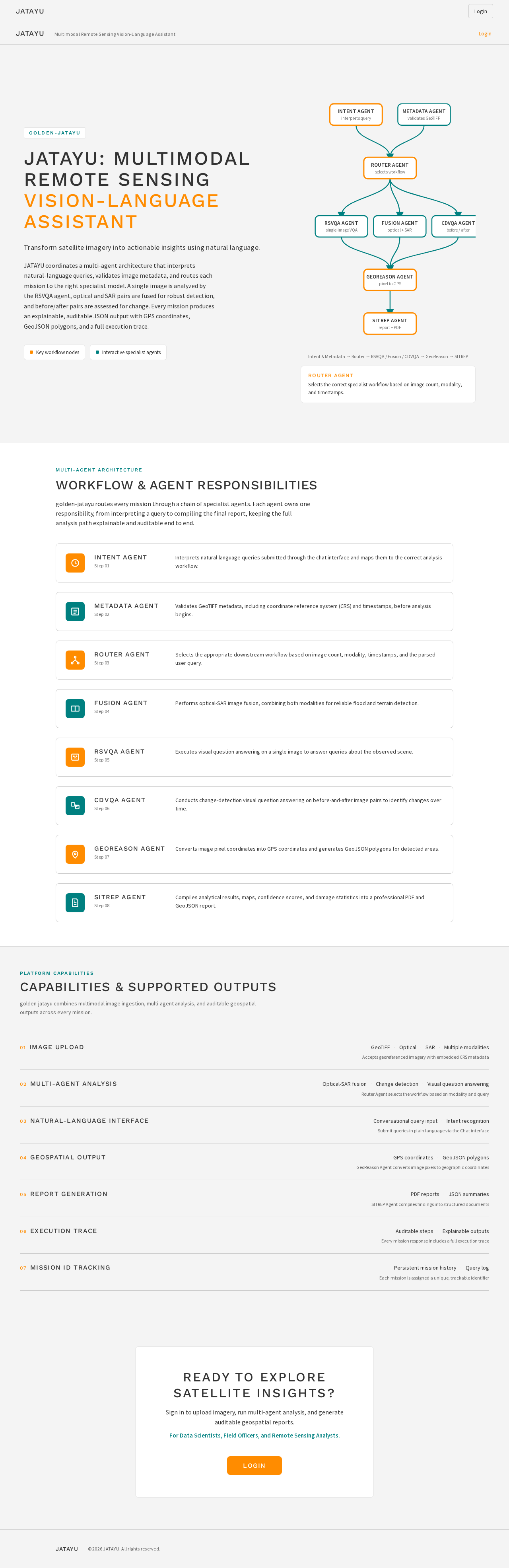
JATAYU: Multimodal Remote Sensing Vision-Language Assistant
Transform satellite imagery into actionable insights using natural language.
JATAYU coordinates a multi-agent architecture that interprets natural-language queries, validates image metadata, and routes each mission to the right specialist model. A single image is analyzed by the RSVQA agent, optical and SAR pairs are fused for robust detection, and before/after pairs are assessed for change. Every mission produces an explainable, auditable JSON output with GPS coordinates, GeoJSON polygons, and a full execution trace.
Intent & Metadata → Router → RSVQA / Fusion / CDVQA → GeoReason → SITREP
ROUTER AGENT
Selects the correct specialist workflow based on image count, modality, and timestamps.
Multi-Agent Architecture
Workflow & Agent Responsibilities
golden-jatayu routes every mission through a chain of specialist agents. Each agent owns one responsibility, from interpreting a query to compiling the final report, keeping the full analysis path explainable and auditable end to end.
Intent Agent
Step 01
Interprets natural-language queries submitted through the chat interface and maps them to the correct analysis workflow.
Metadata Agent
Step 02
Validates GeoTIFF metadata, including coordinate reference system (CRS) and timestamps, before analysis begins.
Router Agent
Step 03
Selects the appropriate downstream workflow based on image count, modality, timestamps, and the parsed user query.
Fusion Agent
Step 04
Performs optical-SAR image fusion, combining both modalities for reliable flood and terrain detection.
RSVQA Agent
Step 05
Executes visual question answering on a single image to answer queries about the observed scene.
CDVQA Agent
Step 06
Conducts change-detection visual question answering on before-and-after image pairs to identify changes over time.
GeoReason Agent
Step 07
Converts image pixel coordinates into GPS coordinates and generates GeoJSON polygons for detected areas.
SITREP Agent
Step 08
Compiles analytical results, maps, confidence scores, and damage statistics into a professional PDF and GeoJSON report.
Platform Capabilities
Capabilities & Supported Outputs
golden-jatayu combines multimodal image ingestion, multi-agent analysis, and auditable geospatial outputs across every mission.
Image Upload
- GeoTIFF
- Optical
- SAR
- Multiple modalities
Accepts georeferenced imagery with embedded CRS metadata
Multi-Agent Analysis
- Optical-SAR fusion
- Change detection
- Visual question answering
Router Agent selects the workflow based on modality and query
Natural-Language Interface
- Conversational query input
- Intent recognition
Submit queries in plain language via the Chat interface
Geospatial Output
- GPS coordinates
- GeoJSON polygons
GeoReason Agent converts image pixels to geographic coordinates
Report Generation
- PDF reports
- JSON summaries
SITREP Agent compiles findings into structured documents
Execution Trace
- Auditable steps
- Explainable outputs
Every mission response includes a full execution trace
Mission ID Tracking
- Persistent mission history
- Query log
Each mission is assigned a unique, trackable identifier
Ready to explore satellite insights?
Sign in to upload imagery, run multi-agent analysis, and generate auditable geospatial reports.
For Data Scientists, Field Officers, and Remote Sensing Analysts.
LoginJATAYU: Multimodal Remote Sensing Vision-Language Assistant
Transform satellite imagery into actionable insights using natural language.
JATAYU coordinates a multi-agent architecture that interprets natural-language queries, validates image metadata, and routes each mission to the right specialist model. A single image is analyzed by the RSVQA agent, optical and SAR pairs are fused for robust detection, and before/after pairs are assessed for change. Every mission produces an explainable, auditable JSON output with GPS coordinates, GeoJSON polygons, and a full execution trace.
Intent & Metadata → Router → RSVQA / Fusion / CDVQA → GeoReason → SITREP
ROUTER AGENT
Selects the correct specialist workflow based on image count, modality, and timestamps.
Multi-Agent Architecture
Workflow & Agent Responsibilities
golden-jatayu routes every mission through a chain of specialist agents. Each agent owns one responsibility, from interpreting a query to compiling the final report, keeping the full analysis path explainable and auditable end to end.
Intent Agent
Step 01
Interprets natural-language queries submitted through the chat interface and maps them to the correct analysis workflow.
Metadata Agent
Step 02
Validates GeoTIFF metadata, including coordinate reference system (CRS) and timestamps, before analysis begins.
Router Agent
Step 03
Selects the appropriate downstream workflow based on image count, modality, timestamps, and the parsed user query.
Fusion Agent
Step 04
Performs optical-SAR image fusion, combining both modalities for reliable flood and terrain detection.
RSVQA Agent
Step 05
Executes visual question answering on a single image to answer queries about the observed scene.
CDVQA Agent
Step 06
Conducts change-detection visual question answering on before-and-after image pairs to identify changes over time.
GeoReason Agent
Step 07
Converts image pixel coordinates into GPS coordinates and generates GeoJSON polygons for detected areas.
SITREP Agent
Step 08
Compiles analytical results, maps, confidence scores, and damage statistics into a professional PDF and GeoJSON report.
Platform Capabilities
Capabilities & Supported Outputs
golden-jatayu combines multimodal image ingestion, multi-agent analysis, and auditable geospatial outputs across every mission.
Image Upload
- GeoTIFF
- Optical
- SAR
- Multiple modalities
Accepts georeferenced imagery with embedded CRS metadata
Multi-Agent Analysis
- Optical-SAR fusion
- Change detection
- Visual question answering
Router Agent selects the workflow based on modality and query
Natural-Language Interface
- Conversational query input
- Intent recognition
Submit queries in plain language via the Chat interface
Geospatial Output
- GPS coordinates
- GeoJSON polygons
GeoReason Agent converts image pixels to geographic coordinates
Report Generation
- PDF reports
- JSON summaries
SITREP Agent compiles findings into structured documents
Execution Trace
- Auditable steps
- Explainable outputs
Every mission response includes a full execution trace
Mission ID Tracking
- Persistent mission history
- Query log
Each mission is assigned a unique, trackable identifier
Ready to explore satellite insights?
Sign in to upload imagery, run multi-agent analysis, and generate auditable geospatial reports.
For Data Scientists, Field Officers, and Remote Sensing Analysts.
Login
No comments yet. Be the first!