golden-jatayu
 Divya Rajput
# JATAYU Backend Architecture Generate a production-ready backend using Python FastAPI. Architecture: ## APIs POST /upload POST /analyze POST /chat GET /mission/{id} GET /report/{id} ## AI Agents IntentAgent MetadataAgent RouterAgent FusionAgent RSVQAAgent CDVQAAgent GeoReasonAgent SITREPAgent ## Context Engine Every mission creates a unique Mission ID. Store: * image paths * metadata * CRS * timestamps * previous queries * GeoJSON * flood masks ## Router Logic If 1 image → RSVQA If Optical + SAR → Fusion If Before + After → CDVQA ## Outputs Return JSON containing: * summary * confidence * area_km2 * gps_coordinates * geojson_path * execution_trace Generate clean modular folder structure and FastAPI routes. Design a LangGraph multi-agent workflow for JATAYU. Agents: Intent Agent Metadata Agent Router Agent Optical-SAR Fusion Agent Change Detection Agent GeoReason Agent SITREP Agent The router must decide the workflow based on: * number of images * modality * timestamps * user query Generate an execution graph and state schema. Output should be explainable and auditable. givme mea full working website

Comments (0)
Sign in to leave a comment
JATAYU: Multimodal Remote Sensing Vision-Language Assistant
Transform satellite imagery into actionable insights using natural language.
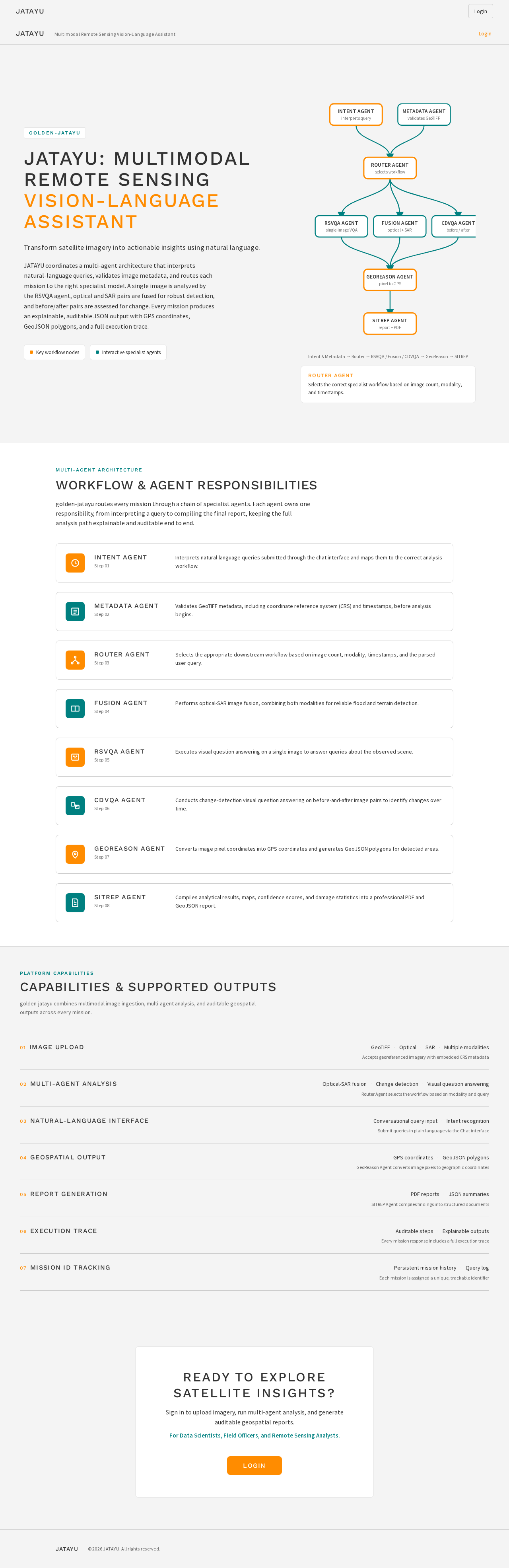
JATAYU coordinates a multi-agent architecture that interprets natural-language queries, validates image metadata, and routes each mission to the right specialist model. A single image is analyzed by the RSVQA agent, optical and SAR pairs are fused for robust detection, and before/after pairs are assessed for change. Every mission produces an explainable, auditable JSON output with GPS coordinates, GeoJSON polygons, and a full execution trace.
Intent & Metadata → Router → RSVQA / Fusion / CDVQA → GeoReason → SITREP
ROUTER AGENT
Selects the correct specialist workflow based on image count, modality, and timestamps.
Multi-Agent Architecture
Workflow & Agent Responsibilities
golden-jatayu routes every mission through a chain of specialist agents. Each agent owns one responsibility, from interpreting a query to compiling the final report, keeping the full analysis path explainable and auditable end to end.
Intent Agent
Step 01
Interprets natural-language queries submitted through the chat interface and maps them to the correct analysis workflow.
Metadata Agent
Step 02
Validates GeoTIFF metadata, including coordinate reference system (CRS) and timestamps, before analysis begins.
Router Agent
Step 03
Selects the appropriate downstream workflow based on image count, modality, timestamps, and the parsed user query.
Fusion Agent
Step 04
Performs optical-SAR image fusion, combining both modalities for reliable flood and terrain detection.
RSVQA Agent
Step 05
Executes visual question answering on a single image to answer queries about the observed scene.
CDVQA Agent
Step 06
Conducts change-detection visual question answering on before-and-after image pairs to identify changes over time.
GeoReason Agent
Step 07
Converts image pixel coordinates into GPS coordinates and generates GeoJSON polygons for detected areas.
SITREP Agent
Step 08
Compiles analytical results, maps, confidence scores, and damage statistics into a professional PDF and GeoJSON report.
Platform Capabilities
Capabilities & Supported Outputs
golden-jatayu combines multimodal image ingestion, multi-agent analysis, and auditable geospatial outputs across every mission.
Image Upload
- GeoTIFF
- Optical
- SAR
- Multiple modalities
Accepts georeferenced imagery with embedded CRS metadata
Multi-Agent Analysis
- Optical-SAR fusion
- Change detection
- Visual question answering
Router Agent selects the workflow based on modality and query
Natural-Language Interface
- Conversational query input
- Intent recognition
Submit queries in plain language via the Chat interface
Geospatial Output
- GPS coordinates
- GeoJSON polygons
GeoReason Agent converts image pixels to geographic coordinates
Report Generation
- PDF reports
- JSON summaries
SITREP Agent compiles findings into structured documents
Execution Trace
- Auditable steps
- Explainable outputs
Every mission response includes a full execution trace
Mission ID Tracking
- Persistent mission history
- Query log
Each mission is assigned a unique, trackable identifier
Ready to explore satellite insights?
Sign in to upload imagery, run multi-agent analysis, and generate auditable geospatial reports.
For Data Scientists, Field Officers, and Remote Sensing Analysts.
LoginJATAYU: Multimodal Remote Sensing Vision-Language Assistant
Transform satellite imagery into actionable insights using natural language.
JATAYU coordinates a multi-agent architecture that interprets natural-language queries, validates image metadata, and routes each mission to the right specialist model. A single image is analyzed by the RSVQA agent, optical and SAR pairs are fused for robust detection, and before/after pairs are assessed for change. Every mission produces an explainable, auditable JSON output with GPS coordinates, GeoJSON polygons, and a full execution trace.
Intent & Metadata → Router → RSVQA / Fusion / CDVQA → GeoReason → SITREP
ROUTER AGENT
Selects the correct specialist workflow based on image count, modality, and timestamps.
Multi-Agent Architecture
Workflow & Agent Responsibilities
golden-jatayu routes every mission through a chain of specialist agents. Each agent owns one responsibility, from interpreting a query to compiling the final report, keeping the full analysis path explainable and auditable end to end.
Intent Agent
Step 01
Interprets natural-language queries submitted through the chat interface and maps them to the correct analysis workflow.
Metadata Agent
Step 02
Validates GeoTIFF metadata, including coordinate reference system (CRS) and timestamps, before analysis begins.
Router Agent
Step 03
Selects the appropriate downstream workflow based on image count, modality, timestamps, and the parsed user query.
Fusion Agent
Step 04
Performs optical-SAR image fusion, combining both modalities for reliable flood and terrain detection.
RSVQA Agent
Step 05
Executes visual question answering on a single image to answer queries about the observed scene.
CDVQA Agent
Step 06
Conducts change-detection visual question answering on before-and-after image pairs to identify changes over time.
GeoReason Agent
Step 07
Converts image pixel coordinates into GPS coordinates and generates GeoJSON polygons for detected areas.
SITREP Agent
Step 08
Compiles analytical results, maps, confidence scores, and damage statistics into a professional PDF and GeoJSON report.
Platform Capabilities
Capabilities & Supported Outputs
golden-jatayu combines multimodal image ingestion, multi-agent analysis, and auditable geospatial outputs across every mission.
Image Upload
- GeoTIFF
- Optical
- SAR
- Multiple modalities
Accepts georeferenced imagery with embedded CRS metadata
Multi-Agent Analysis
- Optical-SAR fusion
- Change detection
- Visual question answering
Router Agent selects the workflow based on modality and query
Natural-Language Interface
- Conversational query input
- Intent recognition
Submit queries in plain language via the Chat interface
Geospatial Output
- GPS coordinates
- GeoJSON polygons
GeoReason Agent converts image pixels to geographic coordinates
Report Generation
- PDF reports
- JSON summaries
SITREP Agent compiles findings into structured documents
Execution Trace
- Auditable steps
- Explainable outputs
Every mission response includes a full execution trace
Mission ID Tracking
- Persistent mission history
- Query log
Each mission is assigned a unique, trackable identifier
Ready to explore satellite insights?
Sign in to upload imagery, run multi-agent analysis, and generate auditable geospatial reports.
For Data Scientists, Field Officers, and Remote Sensing Analysts.
Login
No comments yet. Be the first!