dog-walking-route
 Jonathan Ponciano
Dog walking app that routes where dogs live and also makes a route to them with addition info like distance between and more efficient route


Comments (0)
Sign in to leave a comment
System Requirements
System Requirements Document for Dog Walking App
1. Introduction
Dog Walking App is a route-planning tool for people who walk dogs. It records the home locations where dogs live, builds a walking route that visits those locations, and shows the information needed to judge and improve that route — the distance between stops and a more efficient ordering of the same stops.
The product serves two participants. A Dog owner supplies the home address where their dog lives. A Dog walker plans the walk that reaches those homes, reads the leg distances, and chooses a more efficient route. Both participants must have an account before dog locations or routes are saved, and a returning participant must verify identity before opening saved dog locations or routes.
The audience is small-scale, practical, and route-first: someone who needs clear distance data and a fast route, not a social or booking platform. The interface follows a functional-clarity direction (Dieter Rams): ordered data, honest controls, one signal colour, and no decoration that competes with the route.
2. System Overview
2a. Product Interpretation and Delivery Boundary
The application is a first-party web product with application-owned identity. The public entry is the Landing page, which explains the product and offers the primary action "Plan a route". From there a new participant establishes identity on Sign Up; a returning participant verifies identity on Login. Both identity surfaces are reachable without being signed in, and neither is protected by the state it creates.
Once identity is established, the participant works inside three protected destinations:
- Dog Locations — the saved homes where dogs live, with the distance information attached to each stop.
- Add Dog Location — where a Dog owner saves the home address where a dog lives.
- Route Planner — where a Dog walker builds a route to the saved dog locations, reads the distance between stops, and gets a more efficient route.
All route computation, distance calculation, and route ordering run in the shared backend; the browser only presents state and collects input. Saved dog locations and saved routes are durable, application-owned data held in the provisioned MariaDB database and bound to the account that created them.
Nothing beyond this is in scope. There is no booking, scheduling, payment, messaging, dog profile management, live tracking, or social feed. Route optimisation is limited to producing a more efficient ordering of the stops the walker has selected; it is not a general-purpose navigation or turn-by-turn service.
2b. Source Content Inventory
Not applicable — no reference directive declares content_source.
2c. Page Content and Component Coverage
Landing
- Information and state: Product name and purpose; the hero headline "Every dog on one efficient route"; the subline "Save the homes where dogs live and get the shortest walk between them."; a flat map panel illustrating a green route line with orange numbered stops and leg distances; entry points to Sign Up and Login. Public, no identity required.
- Primary action: "Plan a route" — the orange primary control under the headline; leads an unauthenticated visitor to Sign Up, and a signed-in participant to Route Planner.
- Supporting actions: "Log in" for returning participants; "Create an account" for new participants.
- Domain entities: none persisted on this page; the map panel is an illustration of a route with numbered stops and leg distances.
- Component responsibilities: hero headline block (columns 1–7), flat map panel (columns 6–12), primary CTA, secondary identity links, small-caps section labels.
- States: loading — static content, no blocking load; empty — not applicable; success — CTA routes to the correct next surface based on session state; error — if session state cannot be determined, the CTA falls back to Sign Up and Login remains available; recovery — identity links are always visible so the visitor is never stranded.
Sign Up
- Information and state: Account creation form for a new Dog walker or Dog owner. Public, no identity required. Explains that an account is needed to save dog locations and routes.
- Primary action: Create account — submits the new account and establishes the session.
- Supporting actions: Link to Login for participants who already have an account; link back to Landing.
- Domain entities: Account (identity, credentials).
- Component responsibilities: form fields with small-caps labels above each value, inline validation messages, submit control, cross-link to Login.
- States: loading — submit control shows a pending state and is disabled during submission; empty — blank form with labels; success — session established and the participant is taken to Dog Locations; error — invalid or already-used identity shows an inline message and preserves entered values; recovery — the participant can correct fields and resubmit, or switch to Login.
Login
- Information and state: Identity verification form for a returning Dog walker or Dog owner. Public, no identity required.
- Primary action: Log in — verifies identity and opens the session.
- Supporting actions: Link to Sign Up; link back to Landing.
- Domain entities: Account (identity, credentials).
- Component responsibilities: form fields with small-caps labels, inline error region, submit control, cross-link to Sign Up.
- States: loading — submit control pending and disabled; empty — blank form; success — session established and the participant is taken to Dog Locations; error — incorrect credentials show a single non-revealing inline message and preserve the entered identity; recovery — retry, or switch to Sign Up.
Dog Locations
- Information and state: The saved homes where dogs live, each as a row with the dog's name, the home address, and the distance information attached to that stop. Protected — requires identity.
- Primary action: Open a saved location to review its address and distance data.
- Supporting actions: "Add dog location" (Dog owner) leading to Add Dog Location; "Plan a route" leading to Route Planner with the saved locations available for selection.
- Domain entities: Dog Location (dog name, home address, coordinates, owning account), Distance (between two locations).
- Component responsibilities: data rows separated by 1px hairline rules, small-caps grey labels above each value, circular stop markers, empty-state panel, add and plan controls.
- States: loading — row skeleton with hairline rules; empty — a panel stating no dog locations are saved yet with the "Add dog location" control; success — rows render with addresses and distances; error — a failed load shows an inline message with a retry control; recovery — retry reloads the list without losing session.
Add Dog Location
- Information and state: Form to save the home address where a dog lives, with the dog's name and the address. Protected — requires identity.
- Primary action: Save location — persists the dog location to the account and returns to Dog Locations with the new row visible.
- Supporting actions: Cancel and return to Dog Locations without saving.
- Domain entities: Dog Location (dog name, home address, coordinates, owning account).
- Component responsibilities: labelled fields with small-caps labels, address input, inline validation, save and cancel controls.
- States: loading — save control pending and disabled during submission; empty — blank form; success — the new location appears in Dog Locations; error — an address that cannot be resolved to a location shows an inline message and preserves the entered values; recovery — correct the address and resubmit, or cancel.
Route Planner
- Information and state: The selected dog locations as numbered stops, the route line connecting them, the distance between each consecutive pair of stops, the total route distance, and the more efficient route option. Protected — requires identity.
- Primary action: Build route — takes the selected dog locations and produces a route with numbered stops and leg distances.
- Supporting actions: Select or deselect dog locations as stops; "More efficient route" to reorder the same selected stops into a shorter route; save the route to the account.
- Domain entities: Route (ordered stops, leg distances, total distance, owning account), Dog Location, Distance.
- Component responsibilities: flat map panel with green route line and orange numbered stop markers, aligned distance rows with hairline rules and small-caps labels, total-distance readout, selection list of saved dog locations, primary and optimisation controls.
- States: loading — map panel and distance rows show a pending state while the route is computed; empty — no stops selected shows a prompt to select saved dog locations, with a link to Dog Locations when none exist; success — numbered stops, leg distances, and total distance render, with the active stop marked in orange; error — a route that cannot be computed shows an inline message with a retry control and keeps the selection intact; recovery — retry, adjust the selection, or return to Dog Locations.
3. Functional Requirements
FR-1 — Route to where dogs live (explicit) As a Dog walker, I should get a route that reaches the home locations where dogs live, so that the walk visits every dog I have selected.
- Trigger/input: the walker selects one or more saved dog locations on Route Planner and starts a route.
- Observable result: the route is drawn as a green line through the selected homes, each home marked as a numbered stop.
- Access: signed in.
- Failure/recovery: if the route cannot be computed, an inline message appears, the selection is preserved, and the walker can retry or change the selection.
- Continuation: the walker reads the leg distances and total distance, then optionally requests a more efficient route or saves the route.
FR-2 — Make a route to those dog locations (explicit) As a Dog walker, I should have the app build the walking route to the selected dog locations, so that I do not have to work out the order myself.
- Trigger/input: the walker confirms the selected stops.
- Observable result: an ordered sequence of stops is produced and shown on the map panel and in the distance rows.
- Access: signed in.
- Failure/recovery: a failed build reports the failure inline and leaves the previous route and selection intact.
- Continuation: the walker reviews the order, then reads distances or requests the more efficient route.
FR-3 — Show distance between stops (explicit) As a Dog walker, I should see the distance between each pair of consecutive stops, so that I can judge the effort of each leg.
- Trigger/input: a route exists on Route Planner.
- Observable result: each leg appears as an aligned label-and-value row with a hairline rule, and the total route distance is shown.
- Access: signed in.
- Failure/recovery: if a leg distance is unavailable, that row shows an explicit unavailable state rather than a blank or a zero.
- Continuation: the walker compares legs and decides whether to request a more efficient route.
FR-4 — More efficient route (explicit) As a Dog walker, I should get a more efficient route over the same selected stops, so that the walk is shorter.
- Trigger/input: the walker requests the more efficient route on Route Planner.
- Observable result: the same stops are reordered into a shorter route, with the new order, new leg distances, and new total distance shown; the active stop is marked in orange.
- Access: signed in.
- Failure/recovery: if no shorter ordering is found, the app states that the current route is already the most efficient for the selection; if optimisation fails, the current route stays intact with an inline message and a retry control.
- Continuation: the walker keeps the improved route, saves it, or adjusts the selection.
FR-5 — Save dog locations (explicit, via accepted identity requirement) As a Dog owner, I should save the home address where my dog lives, so that the walker can route to it.
- Trigger/input: the owner enters the dog's name and home address on Add Dog Location and saves.
- Observable result: the location appears as a row on Dog Locations with its address and distance data.
- Access: signed in; the saved location is bound to the owner's account.
- Failure/recovery: an unresolvable address shows an inline message and preserves the entered values; the owner can correct and resubmit or cancel.
- Continuation: the owner returns to Dog Locations and can add another location or open Route Planner.
FR-6 — Review saved dog locations (explicit, via accepted identity requirement) As a Dog walker or Dog owner, I should see the saved homes where dogs live, so that I know which stops are available.
- Trigger/input: opening Dog Locations while signed in.
- Observable result: rows of saved locations with dog name, address, and distance data, separated by hairline rules.
- Access: signed in.
- Failure/recovery: a failed load shows an inline message with retry; an empty account shows an empty-state panel with the add control.
- Continuation: the participant adds a location or opens Route Planner.
FR-7 — Save a route (explicit, via accepted identity requirement) As a Dog walker, I should save a route, so that I can return to it later.
- Trigger/input: the walker saves the current route on Route Planner.
- Observable result: the route with its ordered stops, leg distances, and total distance is stored against the walker's account.
- Access: signed in.
- Failure/recovery: a failed save shows an inline message and keeps the route on screen so the walker can retry.
- Continuation: the walker can reopen the saved route from Route Planner.
FR-8 — Create an account before saving (required_inference) As a new Dog walker or Dog owner, I should make an account before I save dog locations or routes, so that my saved data belongs to me.
- Trigger/input: a visitor chooses "Plan a route" or "Create an account" on Landing, or is directed to Sign Up from a protected destination.
- Observable result: the account is created, a session is established, and the participant lands on Dog Locations.
- Access: Sign Up is public; the destinations it unlocks are protected.
- Failure/recovery: invalid or already-used identity shows an inline message and preserves entered values; the participant can correct and resubmit or switch to Login.
- Continuation: the participant adds a dog location or opens Route Planner.
FR-9 — Verify identity before opening saved data (required_inference) As a returning Dog walker or Dog owner, I should verify my identity before I open saved dog locations or routes, so that only I see my saved data.
- Trigger/input: a returning participant opens Login, or is redirected there from a protected destination.
- Observable result: identity is verified, the session opens, and the participant lands on Dog Locations with their saved data.
- Access: Login is public; the destinations it unlocks are protected.
- Failure/recovery: incorrect credentials show one non-revealing inline message and preserve the entered identity; the participant can retry or switch to Sign Up.
- Continuation: the participant reviews saved locations or opens Route Planner.
4. User Personas
Dog walker
- Product context: Plans a walking route that visits the homes where dogs live. Works from a set of saved dog locations and needs to know how far apart they are before committing to an order.
- Primary goal: Get a route that reaches every selected dog and is as short as it can be.
- Distinct accepted responsibilities: Selects the dog locations to visit on Route Planner; builds the route; reads the distance between stops and the total distance; requests the more efficient route and judges the result; saves the route.
- Relevant inputs and decisions: Which saved locations to include; whether the current order is acceptable or the more efficient route should be applied; whether to save the route.
- Interactions with other participants: Depends on the Dog owner having saved the home address where the dog lives; the walker routes to those saved locations.
- Observable success: A numbered route on the map panel with leg distances and a total, reordered into a shorter route when requested, and saved to the walker's account.
Dog owner
- Product context: Supplies the home address where their dog lives so that a walk can reach the dog. Works from a small, personal set of saved locations.
- Primary goal: Have the dog's home saved accurately so the walker can route to it.
- Distinct accepted responsibilities: Creates an account; saves the dog's name and home address on Add Dog Location; reviews the saved location and its distance data on Dog Locations; corrects an address that cannot be resolved.
- Relevant inputs and decisions: The dog's name and home address; whether a saved location is correct.
- Interactions with other participants: Provides the location data the Dog walker routes to; may also open Route Planner to see the route that reaches the dog.
- Observable success: The dog's home appears as a saved row on Dog Locations with its address and distance data, and is available as a stop on Route Planner.
5. Core User Flows
Flow A — Dog owner saves the home where a dog lives
- The Dog owner opens Landing and reads the headline and subline, then chooses "Plan a route" or "Create an account".
- Because no session exists, the owner arrives at Sign Up, enters account details, and submits.
- The account is created and the session opens; the owner lands on Dog Locations, which is empty and shows the empty-state panel with the "Add dog location" control.
- The owner chooses "Add dog location" and arrives at Add Dog Location.
- The owner enters the dog's name and the home address and chooses Save location.
- The location is saved to the owner's account and the owner returns to Dog Locations, where the new row shows the dog's name, the home address, and its distance data.
- Failure/recovery: if the address cannot be resolved, an inline message appears on Add Dog Location, the entered values are preserved, and the owner corrects the address and resubmits — or cancels back to Dog Locations without saving.
- Continuation: the owner can add another location, or open Route Planner to see the route that reaches the dog.
Flow B — Dog walker builds a route to the saved dog locations
- The Dog walker opens Landing and chooses "Plan a route".
- With no session, the walker arrives at Sign Up (or Login if they already have an account) and establishes identity.
- The walker lands on Dog Locations and reviews the saved homes, including the addresses the Dog owner supplied.
- The walker chooses "Plan a route" and arrives at Route Planner.
- The walker selects the dog locations to visit as stops.
- The walker chooses Build route; the map panel shows a green route line through the selected homes with orange numbered stop markers, and the distance rows show the distance between each consecutive pair plus the total.
- Failure/recovery: if the route cannot be computed, an inline message appears, the selection is preserved, and the walker retries or adjusts the selection.
- Continuation: the walker reads the leg distances and decides whether to request the more efficient route or save the route.
Flow C — Dog walker gets a more efficient route
- From a built route on Route Planner, the Dog walker chooses More efficient route.
- The same selected stops are reordered into a shorter route; the map panel redraws the route line once, the numbered stops update, and the distance rows and total distance update to the new order.
- The active stop is marked in orange, and the walker compares the new total against the previous one.
- Failure/recovery: if no shorter ordering exists, the app states that the current route is already the most efficient for the selection; if optimisation fails, the current route stays intact with an inline message and a retry control.
- Continuation: the walker keeps the improved route, saves it, or changes the selection and rebuilds.
Flow D — Dog walker saves and later reopens a route
- On Route Planner, with a route built, the Dog walker chooses Save route.
- The route — ordered stops, leg distances, and total distance — is stored against the walker's account and the walker sees confirmation.
- Failure/recovery: if the save fails, an inline message appears and the route stays on screen so the walker can retry.
- Continuation: the walker leaves the app. On returning, the walker opens Login, verifies identity, lands on Dog Locations, and reopens the saved route from Route Planner.
Flow E — Returning participant verifies identity
- A returning Dog walker or Dog owner opens Login from Landing or is redirected there from a protected destination.
- The participant enters their identity and credentials and submits.
- Identity is verified, the session opens, and the participant lands on Dog Locations with their saved data.
- Failure/recovery: incorrect credentials show one non-revealing inline message, the entered identity is preserved, and the participant retries or switches to Sign Up.
- Continuation: the participant reviews saved locations, adds a location, or opens Route Planner.
6. Visuals Colors and Theme
The visual system follows the supplied creative direction: functional clarity after Dieter Rams — ordered data, honest controls, one signal colour.
Colour tokens (light mode)
| Role | Hex | Use |
|---|---|---|
| Background | #EFEDE6 | Warm grey ground, ~70% of the page |
| Surface | #F7F6F1 | Map panel, form surfaces, data rows |
| Text | #1C1B18 | Headlines, values, body copy |
| Primary | #2F5D3A | Route lines, primary controls |
| Accent | #E4571B | Active stop and key numbers only; the primary CTA |
| Muted | #7A766C | Small-caps labels, secondary rules, supporting text |
Exactly one accent colour is used. No gradients, no glass panels, no second accent.
Typography
- Headings: Archivo, Medium weight, tight tracking, sentence case.
- Body: Public Sans.
- Labels: small caps at 12px with wide tracking, set in muted grey above every value.
- Modular scale 1.25 — desktop: 64 / 48 / 32 / 22 / 17 / 14; mobile: 40 / 32 / 24 / 18 / 16 / 13. Headline sizes use
clamp()with the mobile size as the floor so text stays whole at 375px, 768px, and 1280px.
Shape and layout
- Rounded rectangles with 8px radii; thin 1px hairline rules separate data rows; circular stop markers with flat fills.
- Strict 12-column grid with visible hairline rules. Left column holds the headline and controls; right column holds the route diagram and distance rows.
- Spacing rhythm on a 4px base with 8/16/24/32/48/64 steps.
Imagery
- Diagrammatic line maps and dog silhouettes only. No stock photography, no photographs of people or dogs. The flat map panel shows numbered stops and leg distances.
7. Signature Design Concept
The public entry is a composed, flat, full-width warm grey ground (#EFEDE6) divided by the 12-column hairline grid.
- A 64px Archivo headline, "Every dog on one efficient route", sits flush left across columns 1 to 7, with the subline "Save the homes where dogs live and get the shortest walk between them." beneath it in Public Sans.
- The orange CTA "Plan a route" (
#E4571B) sits directly under the headline, with "Log in" and "Create an account" as quiet text links beside it. - Columns 6 to 12 hold the flat map panel on surface
#F7F6F1: a deep green route line (#2F5D3A) threading circular numbered stop markers, with the active stop filled in orange and aligned label-and-value distance rows beneath, separated by hairline rules. - Small-caps muted labels sit above every value, as on a Braun control panel. The route line draws once on load; nothing else moves.
The concept recomposes only accepted content — the product name, the hero copy, the primary action, and the route-with-distances illustration — and introduces no new behaviour.
8. Interaction Model & Motion Direction
Interaction Model: Animated Motion Tempo: restrained Hero Dimensionality: flat
Landing Hero Motion Brief
- Focal subject: the flat map panel with the green route line and orange numbered stop markers, with its aligned distance rows.
- Thesis: the visitor's attention lands on the headline and the orange "Plan a route" control; on load the green route line draws once from the first stop to the last, revealing the numbered stops in order and settling the distance rows into place — outcome: the visitor understands that the product connects homes into one ordered, measured walk.
- Motion vocabulary: instant state changes with 120ms linear feedback; a single route-line draw on load; no bounce, no decorative loops, no parallax.
- Composed first frame: warm grey ground, headline flush left across columns 1–7, orange CTA beneath it, map panel occupying columns 6–12 with the route line already partially drawn and the first stop marked.
- Reduced-motion state: the route line, all numbered stops, and all distance rows render fully drawn and static; no draw animation runs, and every control remains in place and usable.
9. Non-Functional Requirements
- Identity and data isolation (required_inference): saved dog locations and saved routes are bound to the account that created them; a signed-in participant sees only their own saved data. Protected destinations (Dog Locations, Add Dog Location, Route Planner) are unreachable without a verified session.
- Durability (explicit — durable state required): saved dog locations and saved routes persist across sessions in the application-owned MariaDB database.
- Route computation latency (required_inference): route building and optimisation run server-side and return a result the Route Planner can render; while pending, the map panel and distance rows show a loading state rather than stale data.
- Readable layout at every viewport (explicit — creative direction): headlines, wordmarks, labels, numbers, and controls stay entirely inside the viewport and their container at 375px, 768px, and 1280px, wrapping or scaling with
clamp(); no element covers readable text or controls. - Reduced motion (explicit — creative direction): with
prefers-reduced-motion, the route line and all data render statically and every control remains usable. - Honest data presentation (explicit — creative direction): an unavailable distance is shown as explicitly unavailable, never as a blank or a zero.
- Single accent discipline (explicit — creative direction): exactly one accent colour (
#E4571B) is used, reserved for the active stop, key numbers, and the primary button.
10. Tech Stack
- Frontend: React application UI, served as the browser client for all six pages.
- Backend: shared FastAPI process hosting the application APIs and domain modules — account identity, dog locations, route building, distance calculation, and route optimisation. New feature APIs extend this existing process rather than adding services.
- Database: MariaDB for application-owned persistent data — accounts, saved dog locations, and saved routes.
- Orchestration:
docker-compose.ymlwith the three provisioned services:frontend,backend, anddatabase. The frontend depends on the backend gateway; the backend depends on the database.
11. Assumptions and Constraints
- A-1 (assumption): A "dog location" is the home address where a dog lives, identified by the dog's name and address; the address is resolved to coordinates for routing.
- A-2 (assumption): Distances are walking distances between consecutive stops, and the total is the sum of the legs.
- A-3 (assumption): "More efficient route" means a shorter ordering of the same selected stops; it does not add or remove stops.
- A-4 (assumption): A participant may hold either or both roles; the persona catalog defines responsibilities, not differentiated permissions over shared state.
- A-5 (constraint): No booking, scheduling, payment, messaging, dog profile management, live tracking, or social features are in scope.
- A-6 (constraint): No stock photography and no photographs of people or dogs; imagery is diagrammatic only.
- A-7 (constraint): The generic indigo/blue-on-white SaaS template is forbidden.
12. Glossary
- Dog location — the saved home address where a dog lives, with the dog's name and resolved coordinates.
- Stop — a dog location included in a route, shown as a numbered circular marker.
- Leg — the segment between two consecutive stops; its length is the distance between stops.
- Route — an ordered sequence of stops with leg distances and a total distance.
- More efficient route — a shorter ordering of the same selected stops.
- Active stop — the stop currently marked in the accent orange on the map panel.
- Participant — a Dog walker or Dog owner with an established account.
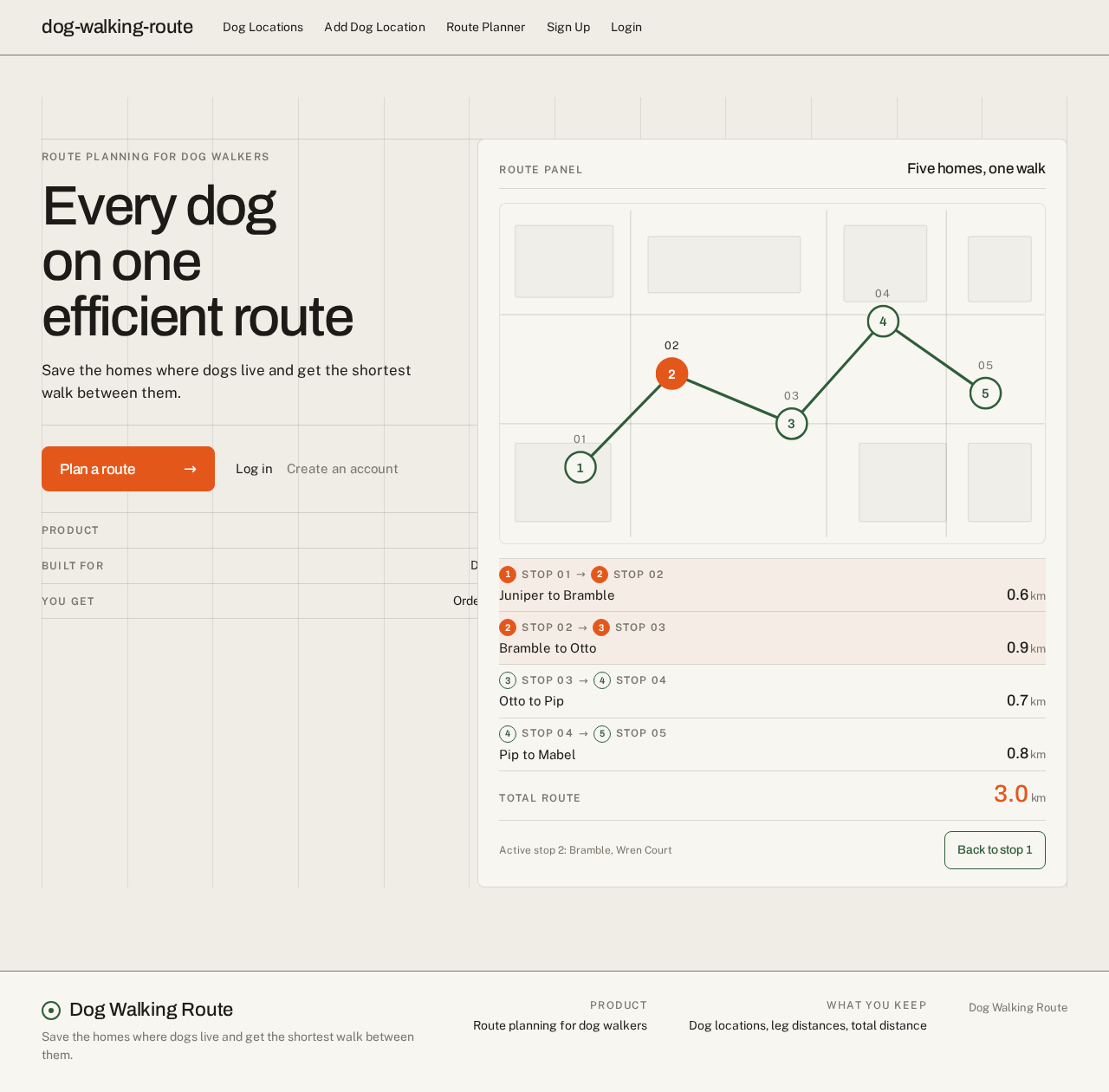
Every dog on one efficient route
Save the homes where dogs live and get the shortest walk between them.
- Product
- dog-walking-route
- Built for
- Dog walkers and dog owners
- You get
- Ordered stops and leg distances
Five homes, one walk
Active stop 2: Bramble, Wren Court
Every dog on one efficient route
Save the homes where dogs live and get the shortest walk between them.
- Product
- dog-walking-route
- Built for
- Dog walkers and dog owners
- You get
- Ordered stops and leg distances
Five homes, one walk
Active stop 2: Bramble, Wren Court
No comments yet. Be the first!