Page 1 of 5
GEo System Requirements Document
Introduction
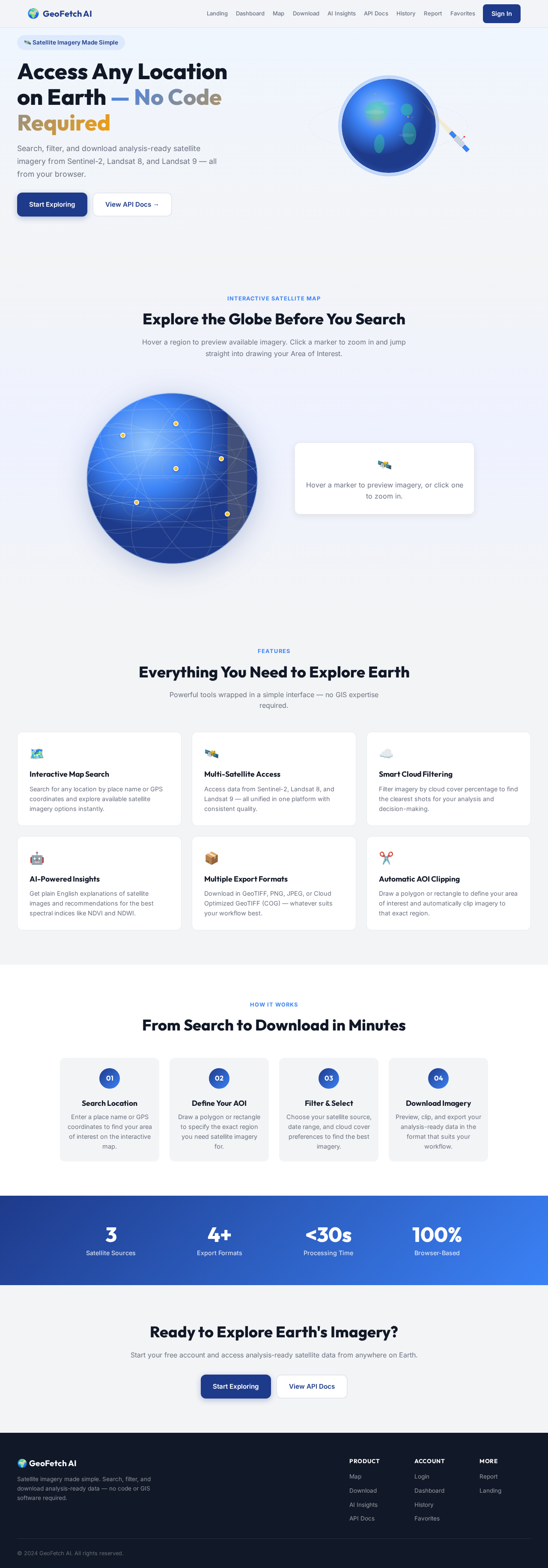
The purpose of this document is to outline the system requirements for the project "GEo," which aims to develop a production-ready SaaS platform named "GeoFetch AI." This platform will enable users to search for any location on Earth and download analysis-ready satellite imagery without the need for coding or GIS software.
System Overview
GeoFetch AI is designed to be a comprehensive web platform that provides users with the ability to search and download satellite imagery efficiently. The platform will feature a user-friendly interface, robust backend services, and advanced AI capabilities to enhance user experience and functionality.
Key Features:
- Interactive map with search capabilities.
- Support for multiple satellite data sources.
- Advanced filtering and image processing options.
- AI-driven insights and recommendations.
- Modular and scalable architecture.
Page 2 of 5
Functional Requirements as Story Points
- As a User, I should be able to search for locations by place name or coordinates.
- As a User, I should be able to draw a polygon or rectangle to define an Area of Interest (AOI).
- As a User, I should be able to select satellite data from Sentinel-2, Landsat 8, or Landsat 9.
- As a User, I should be able to choose a specific date or date range for imagery.
- As a User, I should be able to filter imagery by cloud cover percentage.
- As a User, I should be able to preview selected imagery on the map.
- As a User, I should be able to automatically clip imagery to the defined AOI.
- As a User, I should be able to download imagery in formats such as GeoTIFF, PNG, JPEG, or COG.
- As a User, I should be able to export image metadata.
- As a User, I should be able to save my download history and favorite AOIs.
- As a User, I should be able to receive explanations of satellite images in plain English.
- As a User, I should be able to get recommendations for the best imagery based on cloud cover.
- As a User, I should be able to receive suggestions for spectral indices like NDVI, NDWI, and NBR.
- As a User, I should be able to generate a short report describing the selected area.
User Personas
- General User: Individuals interested in accessing satellite imagery for personal or professional use.
- GIS Analyst: Professionals who require detailed satellite data for analysis and reporting.
- Environmental Scientist: Users focused on environmental monitoring and research.
- Developer: Users interested in integrating satellite data into their applications.
Page 3 of 5
Core User Flows
-
Search and Download Flow:
- User logs in -> Searches for location -> Draws AOI -> Selects satellite data -> Filters by date/cloud cover -> Previews imagery -> Downloads selected imagery.
-
AI Insights Flow:
- User selects imagery -> Receives plain English explanation -> Gets recommendations for best imagery and spectral indices -> Generates report.
Visuals Colors and Theme
- primary: #1E3A8A (Deep Blue)
- primary_light: #3B82F6 (Sky Blue)
- secondary: #F59E0B (Amber)
- accent: #EF4444 (Red)
- highlight: #FBBF24 (Gold)
- bg: #F3F4F6 (Light Gray)
- surface: rgba(255, 255, 255, 0.8)
- text: #111827 (Dark Gray)
- text_muted: #6B7280 (Muted Gray)
- border: rgba(209, 213, 219, 0.2)
Signature Design Concept
Page 4 of 5
Interactive Satellite Map Experience
The homepage will feature an interactive satellite map that allows users to explore the globe in real-time. As users hover over different regions, the map will dynamically update to show available satellite imagery options. Clicking on a region will open a detailed view with options to draw AOIs and select imagery. The map will be enhanced with subtle animations using motion/react to create a seamless and engaging experience.
Landing Hero Motion Brief
The landing hero will feature a dynamic animation where a satellite orbits the Earth, highlighting different regions. As the satellite passes over a region, the map below will illuminate, showcasing available imagery options. This animation will loop every 10 seconds, providing a continuous visual narrative of the platform's capabilities. The animation will be built using motion/react for smooth transitions and interactions.
Interaction Model & Motion Direction
- Intended Interaction Model: Animated
- The landing page will feature moderate scroll-triggered reveals, hover transitions, and spring physics on interactive elements to enhance user engagement and provide a polished experience.
Non-Functional Requirements
- The system must support high availability and scalability to handle large volumes of data and user requests.
- Ensure data security and privacy through robust authentication and authorization mechanisms.
- Maintain a responsive design to ensure usability across various devices and screen sizes.
Page 5 of 5
Tech Stack
- Frontend: Next.js (TypeScript), Tailwind CSS, MapLibre GL
- Backend: FastAPI (Python), PostgreSQL + PostGIS
- Authentication: JWT
- Containerization: Docker
- Environment Management: Docker Compose
Assumptions and Constraints
- The platform will primarily target users in Germany, with localization options available for other regions.
- The system will rely on publicly available satellite data sources.
- The platform must comply with relevant data protection regulations, such as GDPR.
Glossary
- AOI: Area of Interest
- NDVI: Normalized Difference Vegetation Index
- NDWI: Normalized Difference Water Index
- NBR: Normalized Burn Ratio
- COG: Cloud Optimized GeoTIFF
This document outlines the comprehensive requirements for the GEo project, ensuring a robust and user-friendly platform for accessing satellite imagery.



No comments yet. Be the first!